Saturday, November 29, 2014

National transport infrastructure: the importance of a national train system

I speak a lot about Japan on this blog, so I might as well explain where I'm coming from. The intro gives personal background, if you're not interested (I don't blame you), skip to the "End of Background Info" line.

I was raised in the suburb of Boucherville, in a particularly car-dependent area of it (there are walkable areas in the suburb, I was just not in one). Nonetheless, I was never a car lover growing up, I waited a long time to get my driver's license, I was maybe 19 or 20 when I finally decided to get it. Though my area had no retail or services in proximity, it had decent transit service to get to the subway of Montréal and I used transit to get to CÉGEP and university after high school, only driving regularly after getting a job.

Though I didn't think of urbanism much growing up, I recognize that my appreciation for walkable areas is an old one in me. When I was young, I visited the old areas of Québec City and fell in love with it. I told my parents "I can go there and spend days just walking the city and be content that it was time well spent".


Of course, now I know that Québec City is an old, dense European core surrounded by endless North American sprawl. So it is a city full of charm, as long as you keep to the old city and neighboring areas only.

Still, I never really connected this to urbanism much. I even had a phase where I appreciated a lot cars as everyday transport tools and examined the merits of cars a lot, concentrating on fuel economy and efficiency in small cars rather than sports cars. I bought my first car in 2008, the year after I started working, a manual 2.4L Saturn ION 2007 leftover from the previous year. Got a hell of a deal on it too, worth learning to drive stick for it. For 5 years, I did 110 km a day of commuting by car (around 70 miles), 45 minutes each way. Spending my days at work behind a computer and driving everywhere, I gained a lot of weight. Commuting apart, going on a drive was a pleasure of mine, I especially loved driving on forest roads after dark. I didn't speed, I just liked the sensation of driving with the headlights on in the middle of a wild forest on a sinuous road, illuminated by the dashboard lights.

In 2009, a significant event happened which shaped my attitude to transport and awakened me to urbanism. I went to Japan. I had always been interested in and loved Japanese culture, and I admit to being somewhat of an otaku. What I hadn't expected when I went to Japan was falling in love with Japanese cities and its transport system. I was already taking pictures of normal streets and urban areas that most people ignored on my first trip.


5 years later, this photo still cracks me up
I came back to Québec and I told my friends and family: "I left North America seeing cars as freedom... I came back and I looked upon my car as a weight I had to drag around". This tool of "liberty" had become a tool of "oppression" in my mind. Why did I need to get around in a cage of steel and glass that separated me from the world? I realized my world was one of bubbles: my home, my car, my cubicle, and I went from bubble to bubble all day long.

 -END OF BACKGROUND INFO-

OK, so where am I going with this? Well, as I said, my conception of freedom of mobility shifted after a trip in Japan. So why did I feel so free in Japan, much freer than I feel in North America? Hint: look at the title.

Japanese cities tend to be very walkable, which is awesome, thanks to lax zoning which allows developments to follow an economic logic favoring the efficiency of density and proximity and a government that doesn't see as its primary purpose to provide free high-speed roads everywhere. But all this walkability and density would be wasted if people had no way to travel from one area to the other without cars.

That is why I'm not so keen on the "build worthwhile places first... then, maybe, transit" that some New Urbanists are doing. Yes, New Urbanist subdivisions are much better than traditional suburban ones, but in the end, in my mind, they are golden cages. Fine, they are walkable and have nice places, but whenever people want or have to go elsewhere or people from other areas want to visit, they need to take cars. Ultimately, the ability of people to get around is still conditional to the ownership of a motor vehicle.

Even in cities with good transit in North America, the restrictions to mobility are still much felt, because as soon as you leave a certain area, transit service just... stops. You sometimes have coach buses or Amtrak/VIA Rail going to other cities, but all the area between cities is often "off-limits" or extremely hard to reach.

In North America, regional travel is dependent on highways, high-speed roads built by State and provincial governments to allow people to go anywhere. But transit along highways is notoriously bad, highways are built for cars first and foremost (the French word is telling there: "autoroute", literally "automobile road").

In Japan, it is very different. Regional travel depends on an extraordinarily extensive rail system that dominates inter-city travel between 300 and 700 km (200 to 450 miles).
Source
When we talk of trains in Japan, what most people think of is the Shinkansen, the famous "bullet train".

However, shinkansen lines aren't that common, most cities aren't directly connected to it. The real unsung hero of the Japanese transit system is the humble regional rail system which is extraordinarily extensive, and is the reason why when demanding directions on Google Maps for Japan, Google Maps defaults to transit.
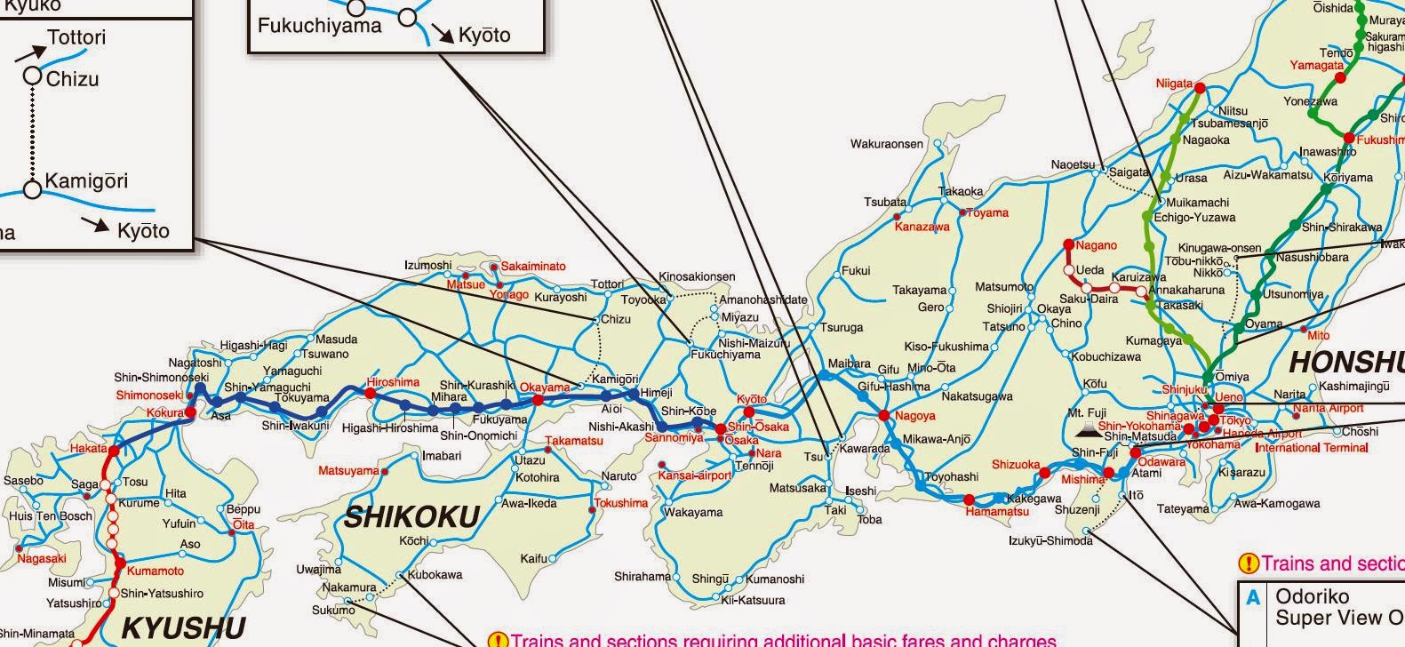
Part of a map of rail lines in Japan
Inside of a regional train, the two boys in white shirts and black pants are likely students going to school, an example of how inter-city trips and commutes overlap on the same trains rather than having two separate systems for commuters and for regional travel

Interior of a train on a private line to Nikko

Regional train station with train waiting

The rail system is essentially as developed as regional highways in North America. Most areas worth going to are connected to rail lines, which is likely due to the fact that cities without rail access see their growth stunted. As a result, there is a feeling once in Japan that you only need to get to a train station, and the rest of the country becomes accessible to you. It may take a while, be expensive and require connections, but finding your way is easy and you know every stop will be well-organized. These trains are why I felt so free in Japan, almost no area is off-limits to people without cars thanks to these rail lines. At least, no area with any significant population. And the stations themselves are located right next to where you want to go most of the time: you get off the train into a pedestrian's paradise, even in small towns, rather than in the middle of nowhere.

Here are some attributes of the Japanese train system which makes it so awesome and which help define freedom of mobility differently.

1- The access points of the system are evident and well-located


Of course, we're talking of the train stations here. Train stations are generally located inside cities themselves, near the downtown area where most jobs and services are located, and at points of high population density. This is largely because developments flow to the train station naturally. In fact, as I mentioned in my last post, in real estate listings in Japan, the closest train station is one of the essential pieces of information provided.

Example of apartment listing on Suumo.jp, with information about nearest train stations front and center, this apartment is in Furano, a town of about 25 000 people, far from any big city
Sapporo station

Kooriyama station
Plaza in front of Nikko train station

Aizu Wakamatsu station

So trains offer downtown-to-downtown travel, most destinations are likely located within walking distance of train stations, and bus services tend to originate from train stations, extending even more accessibility.

2- Taking the train is as easy as taking the subway or a municipal bus


In North America, there is this obsession to differentiate long-distance trips from commuting trips as if the two needed absolutely to be treated differently. It's fine to wait on the platform for a subway or a commuter rail line, but for long-distance lines, it's not. People need to line up at the station and have tickets checked by employees before being allowed to go on the platform where the train is waiting for them. Pure lunacy. Because, yeah, if we want good consumer service, I'm sure airlines are the ones to copy, right?

In Japan, not only can people wait on the platform for any train, even the Shinkansen, but in most cases, there is no reservation needed. You don't need to reserve a seat or buy tickets a long time before. You show up, you look at these boards showing what is the fare to go where you want to go...
Destination and fare board at Kooriyama station
... you buy the ticket at an automatic machine, put it in the machine to get to the platform (and take it back so you can leave at the destination) and you're done. 1 or 2 minutes and you're done, even less if you just use an IC card where you don't need a ticket, just scan it to get in and scan it to get out. Just like taking the subway. It is one system that helps make taking the train a casual experience rather than a special event.

3- The same trains serve both local trips and regional trips


There are expresses, but in many cases, trains stop at all station, even when some are within the same city. This allows regional trains with lines going on for 100 km or more (60 miles) to also be useful for commuters within cities they go across. It's the same train, the same fares apply and it helps to increase ridership for no additional cost as the same service serves both as commuter rail and as regional rail.... just like highways are currently used both by commuters and by long-distance travelers. Again, it means that people going farther out will be taking the same train they may use on their commutes, just stay on it a bit longer. It again helps to make taking the train a casual experience and it means that stations get all-day service, unlike commuter rail in North America that exists only 3 hours a day.

4- Since the rail exists, development grows along the rail lines

This is a bit different from the others as it's not about consumer service per se, but it is very relevant here in keeping areas connected. When cities sprawl in North America, they generally do so beyond the reach of their structural rapid transit system (at least, where it even exists). Developments therefore follow highways to keep a transport connection to the rest of the metropolitan area. In Japan, because regional rail extends far beyond the limits of current metropolitan developments, new developments can follow rail rather than highways.

Let's do this visually, let's take a North American city with both highways and LRT or subways in the central city:

A North American city, the urban area is in grey, highways are the black solid lines, rapid transit is the dotted red lines
When this city's population increases, where will developments concentrate? Well, the new residents still want to have access to the city's services and jobs and so will latch on to currently available rapid transport links, and the only rapid transport links that exist in greenfield areas are... highways.
In yellow, the new developments, concentrated along highways
These new developments will have no transit connection, or a very poor one. It's the perfect recipe for car-dependent development.

Now, let's take a Japanese city, where highways skirt around urban areas and rail lines with constant train service cross the area.

Where will new developments occur? In this case, both rail and highways exist in undeveloped areas, but rail connections lead directly to the downtown area, not highways. So new developments will follow the rail lines that already exist:
These new developments will start with decent, fast rapid transit service to the city from day one. Which will shape the form they take and allows most destinations, even the more recent ones, to reliably be within reach of the rail system.


Bringing this freedom of mobility to North America

OK, the Japanese have us beat, now, can we import this model?

Some would say that we don't have the rail system to do so and it would be expensive to build one... except the truth is North America already has rail lines connecting most cities. Most North American cities built from the 19th century onwards were built along railroads. There is a lot of under-used rail lines or ROW in North America, rebuilding a regional rail system could be largely done by reactivating unused or under-used rail lines. The biggest issues in doing so is that rail lines have been given over to freight train companies which jealously defend their priority on the lines. Personally, I'm of the mind that ownership of the tracks and of train companies should be separated. Currently, freight train companies aren't interested in optimal use of tracks, because doing so would impact their number one business: carrying freight. Passenger rail can then only exist within the holes of freight schedules. The best solution would be to either legally impose the separation of track and train business, so the track owners would prefer to allow as many trains on their tracks rather than favoring one customer over the other, or simply nationalizing tracks (which appeals to my socialist side). The UK and France have this model currently.

The current rail system in North America is like if we allowed freight truck companies to buy highways, and they would then forbid their competitors on them and put quotas on the number of vehicles that could use their highways so as to preserve speed for their own trucks. It would be disastrous for highway capacity and highway-dependent developments... just like the current system is horrible for transit.

Amtrak and VIA would also have to revise completely how they deliver service and end this completely stupid artificial separation between long-distance trips and commuter service. Both can and should be served by the exact same lines.

Some would say still that this is too hard, that we should use the highways we have instead and run buses instead of trains.

Now, the big problem of transit piggybacking off of car-oriented infrastructure is that it is piggybacking off of car-oriented infrastructure. Meaning that the areas that are most readily accessible are car-oriented areas where people get dropped off in huge parking lots far from density and walkable areas. For example, here is a bus stop that I used recently on a vacation in Mont-Tremblant when I decided to take the bus.


Yes, that is just a gas station, without any sign that buses stop there or that you can buy bus tickets there. Why there rather than another gas station? Probably because it's closest to the highway, but how could someone who has never taken the bus know that it's where regional buses stop? They can't unless they do a search on the 'net. And the core of the village is a good 2 kilometers away from this gas station. And there is no information about where you can go anywhere.

Everything that made the train stations in Japan attractive and gave a feeling that you can go places easily is lacking here. The area is not walkable, nor near the downtown area, the area where the network can be accessed is not easily identifiable, and there is no feeling that you are even accessing a NETWORK, you only know there is a bus route, but you don't know anything about it and the network it is a part of. It feels like an ad hoc service, not a real national network of car-less mobility.

Can this be corrected? Probably not, because going to the downtown area in buses at every stop would slow down the service so terribly that it would be completely uncompetitive with cars, whereas trains in Japan are frequently as fast or faster than cars, even the regional trains, since they have exclusive ROW all the way from station to station. Buses can work but only if they act like airplanes: taking you from one bus terminal in the downtown of a big city to another bus terminal in the downtown of another big city, with few or no stops in between, putting off-limits all the areas you travel through.

Conclusion

I think it is important to think about regional mobility without cars, to offer a national transport infrastructure that can link up cities all over the country and tie walkable areas together. This is sorely lacking in North America, there is no such system, though there used to be (because we subsidized its direct competitor, highways, and pushed it to bankruptcy). Otherwise, no matter how good places we build, even if there is decent city transit, it will still feel like a golden cage to people getting around without cars. True freedom of mobility is dependent on a complete train system that is reliable, easily accessible and can easily serve both to go 500 km or to go 10 km away to the next town over.

Such a system also creates a backbone along which development can occur rather than having it sprawl along highways. It's not that most people will use these trains frequently, they may not, but the important thing is: it is there, and people know that it is there and they can depend on it to go almost anywhere they want.

Saturday, November 22, 2014

Incrementalism, height limits and affordable housing

Recently, Charles Marohn from the organization Strongtowns (a pro-urbanist organization that is focused on financially sustainable urbanism, especially small midwestern American towns) published an article about height limits. In it, he spoke about a possible justification for a certain type of height limits that is different from a purely aesthetic argument as is commonly heard. He said that allowing buildings that are very high in areas with plenty of vacant lots can incite the lot owners to ask for much more than they would otherwise for their lots, thus delaying development until another developer figures there is a reason to build high-rises on the site.

This is actually similar to something I mused about on my post about the point of zoning. Indeed, the value of lots is influenced by how much profit can be made developing it, so allowing higher density developments do increase land value, especially if high density developments is allowed only in a select few areas. This might contribute to the "stonehenge" feel of some areas I saw in Sapporo on my trip there:
"Stonehenge"-style of development in Sapporo, 10+-story towers next to vacant lots and parking lots
He then recommends a dynamic form of height limits, where height is limited not arbitrarily but in relation to the height of adjacent buildings, he suggests 50% higher than the average of the buildings on adjacent lots. Which, again, strangely echoes my own musings about dynamic zoning.

First things first, the good thing about this idea: it supposes that cities must evolve rather than be set in stone and gradually become denser. It also encourages the construction of tight urban fabric and small-scale redevelopment. And it might indeed be sufficient to tame densification in certain sensitive areas to make it more palatable.

However, is it really a good idea everywhere?

Economics of redevelopment

The biggest issue I have with the 50% rule (yes, even if I came up with it myself too) is that if you take an uniform area all with 2-story buildings where demand for housing outstrips supply, 50% increase in density is not going to allow for affordable new units (not unless you can add floors to existing buildings). Each new unit in redeveloped buildings has to incorporate in its price part of the value of the units it replaces.

For example, if a 2-story building is worth 400 000$, a 3-story building built over it will need to incorporate that 400 000$ in its sale value, so if the new building has three units and each of these units cost 150 000$ to build, then they will need to be sold for 290 000$ at a minimum to be profitable, that is nearly twice the cost of building a similar building in a greenfield development. That is a significant barrier to redevelopment.

Curb showing how more expensive redeveloped units are in relation to construction costs and the allowed density increase
But the reality is even worse. In the previous example, I supposed that the current value of houses was equal to their construction cost. That is correct in balanced housing markets where there is plenty of land to develop and supply can organically grow to respond to demand, but in places in high demand where redevelopment is more likely, that's not the case at all, housing is in shortage and its value will therefore likely be higher than the initial construction cost.

Furthermore, if I was correct in my earlier posts and that the ceiling of value of housing in a given area is defined by the marginal cost of building new housing, then that means that if the cost of building new units is much higher than the construction cost of the existing units, then the market value of existing housing will be free to increase up to the cost of building new units, for the economics don't support redevelopment until market value goes over the cost of redevelopment.

What I mean is that if in the uniform 2-story area each unit is worth 150 000$ and building a new unit to the same construction standard in a 3-story building would cost 250 000$... who would actually buy those units when they could have units worth 150 000$ instead? These new units will not move, unless people are willing to pay 250 000$ for them, and if they are, then that means that the value of all the existing units, barring massive flaws and disrepair, would also be 250 000$. In other words, it's only when existing unit prices will be 250 000$ for existing units that it will become worthwhile to build new units...

BUT WAIT! There's more. Since the value of existing units influences the cost of building new units, it means that if current units are worth 250 000$, then the cost to build new units in 3-unit buildings is no longer 250 000$, but rather 315 000$! So now existing units can increase in value to 315 000$ before building a 3-unit building in replacement of a 2-story building becomes worth it... but if that's the case, then the cost of building these new units is now up to 360 000$!

Ouch! I still have good news for you: it converges at one point. At one point the cost of building a new unit does become equal or lesser than the current market value of existing units. At what point?

Here's the graph that shows at what point it happens.
Ratio to construction cost at which point a new unit built in replacement of existing units can cost less to build than current value of existing units (dotted red line is the previous graph)
So for example, if you allow only a 50% density increase (2 to 3 units) and the cost of building each unit is 150 000$, excluding land costs, then the value of existing units can be 3 times as high before it becomes profitable to build new units (ratio of 300%). So units will need to increase in value to 450 000$ before you start seeing some redevelopment that is affordable for the people who could afford to live there at current prices (if you are willing to move upmarket by building luxury units, redevelopment can occur sooner).

Gradualism the like of what was proposed in the Strongtowns article thus has a terrible flaw: it is economically unaffordable. Filtering may help to some extent, with existing units falling in value because newer units are seen as more desirable, so it needs not be that bad, but even then, we are far from affordable housing for all. The economics of redevelopment may make such a rule almost completely ineffectual, unless housing prices are extremely high.


No possibility for higher densities where needed

One of the big problems of such a blanket rule would be that areas can't simply leapfrog the steps of density. For instance, if you have just built rapid transit passing through a low-density area, the rule would allow only for a small increase in density, far less than would actually be required to take full use of the area's opportunity. But you need to be able to concentrate as many stores, jobs and residents near transit stations to make them worthwhile and reduce the need of cars to reach popular destinations.

So to increase density very fast, developers would have to build a taller building, then build an even taller next door and destroy the first building to build an even taller one. Needless to say, that's absurd. I don't believe the idea that buildings should be eternal, I've defended the Japanese way of treating housing as depreciating goods like cars, but even I recognize that you want your housing to stay up at least 20 years, otherwise it's a complete waste.

The Rosslyn-Ballston corridor in Arlington, a Washington DC suburb. The area went from a suburban commercial strip to this after the subway came, it didn't go through progressive 2-,4-,6-story phases to get there. It is one of the rare suburbs in North America where population has increased, jobs have increased and traffic has gone down
The problem of such a rule for transit-oriented developments was brought forth to Charles Marohn by many, including by me. However, it turns out that he didn't see it as a bug in his system, more like a feature. Marohn doesn't believe in TOD, he explicitly said in a discussion:

"I'm not an advocate of TOD but instead DOT, development-oriented transit."

He frequently calls cities building rapid transit lines to areas where the current state of development doesn't justify rapid transit currently a "gamble" with public money and is strictly opposed to it. So if I understand his position correctly, he wants development to first grow to a sufficient density to support rapid transit, then it may be built. So his rule in that approach is not a problem at all, areas where high-quality transit will be built will already have high density, so 50% more of high-density is quite sufficient in his mind.

Now with all due respect, I would ask: how exactly is this "development-oriented transit" any different from what we've been doing for the past 70 years? This is why there was so much dearth of actual transit investments. Rapid transit generally requires more density to be financially viable than car-oriented developments can support. So of course, in an era of car-oriented development, the only areas that got transit were areas built before the car in old streetcar suburbs. So that idea is nothing new and, especially, a sure approach for failure from my point of view.

Not only that, but I think his approach is also a gamble. Because if (despite my predictions) density does get high enough to justify rapid transit, then that rapid transit line will be supremely expensive to build through an high-density area with sky-high land prices. Almost the only way to build a rapid transit through such an area is underground, which costs 200 to 400 million dollars per km.

On the other hand, if you build rapid transit on the surface before the area gets built up too much, then the cost of construction for a line that offers similar speed and level of service is probably around 30 to 50 million dollars per km, almost 8 times cheaper. 8 times cheaper also means that the density level justifying the line is also 8 times smaller. So putting off transit investments is also a gamble, but instead of betting on transit as a major way of getting around, you're instead betting that it will never be justified and that cars will remain the long-distance transport mode forever. If an area grows so much it now requires rapid transit and you have put off investments for years, then you have lost the bet: you thought you could save money by not investing in transit, and you were wrong, now you have to build transit at 2 to 8 times the price of what it could have been if you had invested money earlier, or your city will choke on cars.

The presence of rapid transit stations also give developers a reason to build density around them, when it would be much cheaper for them instead to let old neighborhoods die and to build in greenfield areas where land is cheaper.

For example, the strong regional train system in Japan is no stranger to the fact that all cities develop mainly around their local station. The presence of the station is what draws developments there and it allows people to be free to go to any city without using cars.

Japan's JR rail networks (doesn't include private lines)
Down this street, the Kitami train station, which creates a strong downtown area even in this city of  126 000 people.
In fact, one of the first informations on real estate listings on Japanese websites, after the price and the number of rooms, is how far to the nearest station the unit is. 
Example of apartment listing on Suumo.jp, with information about nearest train stations front and center, this apartment is in Furano, a town of about 25 000 people, far from any big city

Salvaging incrementalism

Still, I think I may understand where Marohn is coming from. An engineering background may explain why both he and I find attractive the idea of simple rules to follow in every situation rather than byzantine arbitrary regulations that carve up cities and countries in tiny pieces where rules vary based on no quantifiable criterion. The kind of absurd situation where one lot may have an height limit of 3 stories when the one next door has an height limit of 2 stories, simply because some planner decided to do it that way without reason way back when and now you need to actively work to change it.

So can incrementalism be saved while taking into account the economics of it and allowing for TOD, bursts of increased density leapfrogging the stages of development, while achieving Marohn's aims to favor the construction of urban fabric rather than stonehenge-style development?

I think so.

The way to do this in my view is that instead of making the height limit dependent on adjacent buildings, it would vary first and foremost by what is present on the lot currently. Meaning that instead of going by the average height of adjacent buildings, you'd use a multiple of the height of the current building, or better yet, by its FAR (floor area ratio: the sum of the area of each floor divided by the lot area). And in order to keep prices from raising too high, going by the second curve I posted, I would recommend an allowance for twice or thrice current FAR, with a preference for thrice.

For vacant lots, buildings should be limited to the average height of current buildings or to 2 stories (or 40% FAR).  This way, keeping a vacant lot would be a waste, because the profit linked to the development of it would be strictly limited to relatively low-density developments, since only developed lots could be transformed into high-density developments.

What would this mean?

Well, let's rake a typical bungalow (all models made in Sweet Home 3D that I've diverted from its true purpose and towards making up different densities and building dense neighborhoods):


This is about 25-30% in FAR, so a 150 square meter (1500 square foot) house on a 600 square meter lot.

If you want to replace this bungalow with higher densities, you could go for row houses...
Three row houses with parking spaces on a driveway, FAR 60-70%
 ...or go the multi-family route with a triplex:
Triplex, FAR 70-80%
If the triplexes and row houses no longer suffice, then they can be converted to 3-story, 12-condo buildings, with a FAR of around 200%.


Later on, you could go even taller if needed.

What of TOD and higher density "bursts" then? Well, you could put a rule saying that any developer that wishes to go beyond thrice the FAR of the actual building to pay a penalty fee equal to the value of the current property times the ratio between the current FAR of the building and the needed FAR it would need to be able to build the future development.

Okay, an example would be better...

Let's say you have a 2-story duplex worth 600 000$ and a developer wants to build a 9-story condo tower in its stead. Normally, with a "3 times FAR" rule, only a 6-story building would be allowed (supposing the same lot coverage). The building on the lot would have needed to have 3-stories for it to be allowed. In other words, the current building should have 50% more stories to allow the 9-story building, so the developer has to pay a development fee of 50% of the current value of the duplex in order to have the permit to build the 9-story condo tower, in this case, that's a 300 000$ development fee.

There, you have an incremental rule that:
  1. Keeps the value of land down for vacant lots to favor development of them
  2. Allows for incremental density in reaction to demand
  3. Makes sure that increased density is sufficient to maintain housing somewhat affordable even when built by replacing existing housing
  4. Allows a way for developers in areas with exploding demand to go beyond the incrementalism when they need to leapfrog the stages of development

Monday, November 17, 2014

Malls and urbanism

One of the biggest musical hits of the 90s in Québec was "La Rue Principale" by the group "Les Colocs" ("the Roommates"). The beginning of the song went like this:

Dans ma petite ville on était juste quatre mille
Pis la rue principale a s'appelait St-Cyrille
La Coop le gaz bar la caisse pop le croque-mort
Et le magasin général quand j'y retourne
Ça me fait assez mal!
Y'est tombé une bombe sur la rue principale
Depuis qu'y ont construit: le centre d'achat!
-Les Colocs, la Rue Principale

Translated in English, it would be this:

In my small town, we were just 4000
And the main street was called St-Cyrille
The Coop, the gas bar, the credit union, the funeral home,
And the General Store! When I go back
It makes me hurt so bad!
A bomb has fallen on main street
Since they've built... that shopping center!
-Les Colocs, la Rue Principale

The group sang of course of the collapse of traditional main streets and the rise of one of the most well-known symbols of North American suburbia: the mall.

Promenades Saint-Bruno, the biggest mall near me when I grew up
Malls came to be with the car era when the transport patterns of people shifted to highways and high-speed roads, many of them built in previously unbuilt areas. Developers built huge interior commercial areas near high-speed roads, areas with plenty of traffic and within short travel time from plenty of car-owning households. Big stores ("anchors") were included in the mall, as well as plenty of small commercial locals that could be rented by small stores, that would thrive on the traffic drawn by the "anchors" and the proximity of each other. As land was very cheap, plenty of parking could be built for a very low price.

Meanwhile, traditional main streets often collapsed into irrelevancy. With people going there less and less, and parking requirements making it harder and more expensive to invest in downtown areas, as malls rose, main streets fell.

Consequently, malls were often demonized as one of the pillars of sprawl and car-dependence. To be fair, they were easy to hate, with their huge parking lots and their gigantic blank walls, seemingly breaking every rule of good urban design (fast roads, plenty of surface parking, hard to access without a car, blanks wall all around, etc...).

The inherent weakness of malls

A new phenomenon has happened in recent years: the death of malls. Malls which lose their tenants one by one until the mall become desert and closes. This revealed a fundamental weakness of malls: as they rely on speed rather than proximity to obtain their clients, they become extremely sensitive to congestion and to competition from newer malls at other highway exits.

Since they tend to be far from most of their customers, malls rely on high-speed roads to be within reasonable distance of their clients. However, if through traffic on these high-speed roads increases and causes congestion, reducing the speed that people can travel at, then the mall practically "drifts" away from its clients since it takes more time to get to it. A trip that used to take 10 minutes can now take 15 or 20 minutes. The area the mall reaches suddenly becomes much smaller.
A mall at an highway interchange and the areas within 10 minutes of car travel of it, in blue the area if the highways are uncongested (100 km/h), in red the area if the highways are congested so that average speed is down to 60 km/h.
Also, the location near highways and other high-speed roads is also a curse as it means all malls opening within a few kilometers effectively compete directly with an existing mall, because the speed on the highway means that it takes little time to travel between malls at different exits. If two malls are within 5 kilometers (3 miles) of each other, it takes just 3 minutes to travel from one to the other (at least on uncongested highways). That is the equivalent of two stores within 200-300 meters (700-1 000 feet) of each other if people were walking. So if one mall is rather rundown and a new mall is built within a radius of 5 kilometers, it is likely to cannibalize many of the earlier mall's clients.

Since much of a mall's attraction is dependent on the diversity of stores that reinforce each other, as stores close or move to greener pastures, there is a vicious cycle of stores closing leading more and more people to flee to other malls, accelerating the decline of the stores that remain.

This is unlike commercial streets in dense cities, which tend to remain strong because they have the advantage of proximity with a lot of clients who reside within easy walking distance of them. This guarantees a certain patronage that can usually maintain these streets (unless the population declines).

Are malls inherently anti-urban?

As I said in the intro, malls have been associated with sprawl for decades. But is it a fair association that can never be broken?

After all, if we look at malls and break down what they really are, aren't they pedestrianized commercial areas where one may park once then hang around all they? And indeed, in suburbia many teens took to spending their time at the mall, like previous generations did at town squares and markets, creating the name "mallrat" (which spawned some movies and TV series, notably Kevin Smith's "Mallrats" and the Canadian animated series "6teen", which both illustrate malls as self-contained towns with their own rules and dynamics where protagonists spend their days).

Thinking about it, one could describe malls as essentially the commercial main streets taken outside of cities and put inside one big building. But otherwise, the commercial street is still there, with plenty of small commercial locals for rent, with retail and restaurants, even public plazas and fountains, just like cities. Malls in one way are the commercial part of downtown removed from downtown and put at the periphery of urban areas.

Once you exclude the parking, malls also reveal themselves to be very dense commercial areas, often with a second floor allowing them to pack more commercial space in as little a footprint as possible. Okay, they often do that to have more space for parking, but the same principle could work in an urban area in order to reduce the footprint of a mall and allowing an insertion inside urban areas.

For example:
10-story mall in the center of Kooriyama in Japan, a city of around 350 000 people
So it is very possible to have urban malls, as long as the area around is either very densely populated, well-connected through the transit system and/or that people coming by car are willing to pay for parking in multi-storied structures or in underground parking.

Malls can be a way to add big popular stores in urban areas devoid of them. Not everyone will like it as it may make things harder for local stores due to the competition, but is it better to have an urban mall next to transit nodes or to have malls in car-dependent areas with people inside cities buying cars and using them to go to these malls?

That is not to say that malls are the best way to build commercial areas into cities. Malls tend to complement streets poorly, they suck life out of them by bringing people inside rather than allowing them to mingle outside (a privatization of the public realm), which, to be fair, might be a blessing in extremely hot or cold cities. Traditional commercial streets are more organic and can change piecemeal, whereas malls tend to be hard to change as they're one big building and they feel "artificial". So aesthetically, malls are far from great, yet they can still function as boosts to walkability if used in the right spot because they are walkable commercial areas.

They are also a much lesser evil than the recent alternative that has sprouted up: the so-called "power center", which is completely car-oriented. Say what you want about malls, their location may be car-oriented, but once there, you walk from store to store, it's human-scaled inside. Power centers are not only in car-oriented areas, but their stores are spread apart around huge parking lots. So not only do you need a car to get there, but you also need a car to go from one store to the next, a completely car-oriented shopping environment.
A power center in all its ugliness
A personal loose typology of shopping areas (all examples from the region of Montréal)
The fact that malls are by themselves walkable, dense commercial areas mean that they can be retrofitted into urban areas. It isn't easy, but it can be done, by a combination of building transit links to it so people don't need cars to get there (note that apart from the highest density cities in the world, the idea of malls thriving based mostly on clients living within walking distance is naive, so transit is required, or bikes at the very least), building parking garages to replace all the surface parking (the mall will need continued car patronage while it is being retrofitted), then filling the rest of the parking lots with offices and high-density housing. As they are frequently in greenfield areas, there is also plenty of room for growth around.

Theoretically, a mall could become the "seed" for the downtown of a new city. However, I am not aware of any area that has successfully achieved such a transition. I know that Mississauga in Ontario is attempting it, building high-rise condo towers around its existing malls.
High-rise condo towers being built in relative proximity to a mall in Mississauga
Square One mall in Mississauga City Center, with nearby towers
For the moment, from what I hear, the results are not all that great. The towers are still within "car proximity" rather than "walking proximity", not helped by the gigantic patches of asphalt in the form of parking lots and enormous stroads.

Friday, November 14, 2014

The density of density: should density be uniform in cities or variable and concentrated?

In an earlier piece, I had explained why density was important, and even used trip survey data in Québec to plot the percentage of trips made by car versus neighborhood density, which  revealed a strong linear relationship between the two:
Auto mode share (y-axis) vs residential density (x-axis, people per square kilometer)
Density is of course measured by the population residing in a given area. However, this obscures a more complex reality of the distribution of density around the area. Two areas can have the same overall density, meaning the same population over the same area, but have wildly different patterns of density: one may be of uniform density over the entire area, with just one type of housing, the other may have great housing variety, with very dense apartment blocs in certain areas and large single-family houses in others.

So, which is better? The uniformly dense city or the unevenly dense city?

A lot of urbanists in North America are very classical, craving order and uniformity, their models are European cities with buildings of the same height built close together. I think the country that exemplifies this best is actually the UK. From what I understand, the UK has a very centrally planned form of urban development, with cities drawing up plans and all developments requiring planning permissions on a case-by-case basis, making planners extremely important and resulting in very similar developments, with a marked preference for semi-detached housing and row houses. Indeed, nearly two thirds of the British population live in such housing, and there is very little multi-family development:
Shares of population living in each dwelling type (RoC=Rest of Canada, apart from Québec)
This mode of development is most flagrant in London where many subway stations are stuck in uniform neighborhoods of row houses without any dense node anywhere. On the other hand, we have the Japanese model which is much more chaotic and tolerant of varied housing types.

For example, here is Sudbury Town station, about 15 km west of London's CBD:

Overhead view of Sudbury Town station, 15 km west of London's CBD
Closer view of station
As you can see from these aerial shots, developments seem planned, with great uniformity in housing stock and seemingly no particularly dense housing, offices or retail near the station itself. In fact, if you were to take the northern exit of the station, here is what you would see:

Google Street View from Sudbury Town station
Housing doesn't vary all that much, with row houses and semi-detached houses being ubiquitous, demonstrating well the bias of British planners towards this type of housing.
This is right next to the station

A bit further out

Still a bit further out
Now let's compare this with Tsutsujigaoka, a Tokyo train station 15 km out west of Tokyo station. It's not technically a subway station, but with trains coming in at headways of 5 minutes all day in both directions, it could as well be.

Overhead view of Tsutsujigaoka station

A closer view of the station and the high-density node around it
I hope you can see clearly how there is significant contrast between areas close to the station and those further out, with 10-story buildings right next to it and largely low-rise areas a bit further away. You can also see in the first pictures what seems to be a danchi (public housing) "village".
View from station's northern exit... contrast with Sudbury Town's
 As to housing, here is some typology of it:
Right next to station, tall condo towers, often with retail on ground floor


Low-rise single-family area away from the station

Just for curiosity's sake, the danchis down south
The British example is much less dense near the station, yet the row houses and semi-detached homes are a bit denser than the single-family areas of the Japanese example.

A thought experiment

Now that I've illustrated the two models, of uniform density and concentrated density, let's do a thought experiment. Let's take two neighborhoods, with a major destination point at the center (retail, transit station, whatever), one of them has uniform density with 2- or 3-story buildings, with 10 000 people per square kilometer (much less in the commercial center) and another with tall condos/apartments in the center, surrounded by lower-density single-family areas. In effect, the density will vary between 30 000 and 6 000 people per square kilometer.

To the left, the uniformly dense neighborhood, to the right, the one with varying density
Both have the same population of about 19 000 people. If you calculated population over the area, you'd conclude that the uniformly dense neighborhood is actually denser, with 9 800 people per square kilometer versus 8 300 for the second. This is how density varies according to distance in the two neighborhoods:
Now let's say I want to predict how likely people are to walk to the center of the neighborhood. Walking, as is instinctively evident, is very sensitive to distance. If you have to go next door, you are going to walk all the time (unless you live in a rural area where the next door is a couple of kilometers away). But as distance increases, the probability of walking decreases quickly. I have tried but failed to find data showcasing walking mode according to distance relevant to this thought experiment, so I just made this curve. NOTE: do not quote me on this curve, I literally pulled it out of my ass, just going by what I think should be true.

Using the two previous graph and the data at their base, I calculated the total probability of walking for the entire population by taking each slice of the neighborhoods and multiplying the population by the probability of walking based on average distance to center. This is what I obtained as a result:

Uniform density: 26% probability of walking to center
Varying density: 36% probability of walking to center

The reason is simple: though overall the second neighborhood is less dense, since it's much denser in the center, more people live really close to the central area than in the uniformly dense neighborhood, where density is even lower in the center than farther out because building height is the same everywhere but retail occupies a large part of the floor area in the center. And since the probability of walking is much higher if distance is smaller, then it's much better if you can get as many people to live as near to the concentration of destinations as possible.
Cumulative population living within distance of center
Note also that the average density I calculated previously was the typical average density, dumbly dividing total population by total area. This is not very representative of the density the average person experiences. It is much better to calculate weighted density. This gives more weight to denser areas. Calculating is means dividing the area into smaller blocks, calculating the density of each of these blocks, multiplying the density by the population, adding all these totals together and dividing by the total number of people.

Visually, it means this: If I plot the density of neighborhoods over the cumulative population of the two neighborhoods:
 ...the weighted density is the value for which the areas between the curve and the value equal out top vs bottom (here, the light blue and dark blue areas both are of the same size).

Doing it this way, the weighted density of the uniformly dense neighborhood is 9 900 per square kilometer, and 10 700 for the neighborhood of varying density. It reverses the previous averaging result, and is a better representation of the average density people live at.

Of course, this works if the higher density areas are near the commercial area/train station/other common destinations of trips. If density varies, but is less near the center and higher at the fringe (like, you know, Radisson station in Montréal), this is far worse than the uniform density case.

And indeed, this impact of density distribution seems to have measurable impacts. Whereas Tokyo's subway lines have respectively riderships of 12 and 8 million riders per km of track, London's Tube only has a ridership of 3 million riders per km of track per year. Another impact is that buses in Tokyo have very low ridership, but in London, since people live on average farther from subway stations due to the absence of high-density multi-family housing near most of them, buses are more used than subways, however bus trips are very short (1,6 mile on average in 2001 according to this data... sounds like a last mile problem).

Conclusion

As the most efficient mode of transport is walking and walking is very distance-sensitive, if we want to maximize the mode share of walking trips, then it is important to be ready to allow higher density developments near popular destinations: offices, groceries, transit stations, etc... The idea of uniform density, if it appeals to some's sense of aesthetics, is not as efficient and it doesn't respond to people's actual desires, with the supply of housing in highly desirable areas being artificially limited to be equal to the supply of housing in undesirable areas of the same size. More efforts should be put towards increasing density significantly near commercial/job/transit nodes rather than increasing the density of all neighborhoods at once.